|
Different planet in our world; Cappadocia..
|
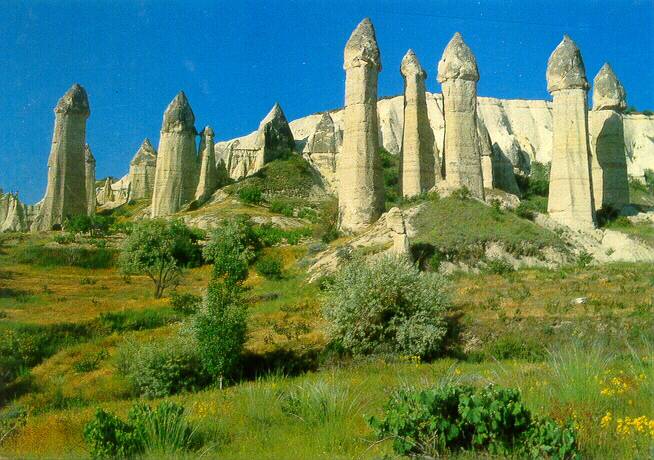 Amour Valley!
|
|
http://www.seyahatname.150m.com/
CAVETOWNS AND GORGES OF CAPPADOCIA
For millions of years, the mighty volcanoes of the Central Anatolian Plateau erupted and spewed their contents across the land that would become the cradle of civilization. Blessed with a moderate climate and fertile soil, one of the world's earliest known communities was founded 10,000 years ago at Catalhoyuk along the river banks of the Casambasuyu near Konya. Mankind's first nature painting was found here and it portrays the most recent eruption of Hasan Dagi almost 9000 years ago. Today, its snow capped peaks dominate the Konya plain, awash in golden hues where vast wheat fields blend subtly with the ochre colored soil and the monochromatic palette is interrupted only where rivers flow and tall poplars flaunt their greenery.
Another great volcano rises in the distance to the east of Hasan Dagi. Once called Mt. Argeus, the awesome presence of Erciyes Dagi inspired legends as the "Abode of the Gods" and the Persians built a Zoroastrian fire temple nearby. These two ancient volcanoes mark the western and eastern boundaries of a region known for its curious volcanic landscape that has been relentlessly carved by nature and by the people who have lived here. 'Fairy chimneys,' cones and strange rock formations have been sculpted by wind and rain while subterranean towns were excavated by a populace seeking shelter from the conquerors and would-be conquerors who crisscrossed the wide open steppes of the Central Anatolian Plateau. Ancient Anatolian tribes, Assyrians, Hittites, Phrygians, Turkic tribes from Central Asia, Mongols, Persians, Syrians, Arabs, Kurds, Armenians, Slavs, Greeks, Romans and Western Europeans have all passed through leaving behind some of their traditions as well as their genes and rendering Cappadocians as exotic as their surreal surroundings.
Although the Hellenistic kingdom of Cappadocia once encompassed a much greater area, the name now refers to the region east of Konya that is defined by Aksaray to the west, Kayseri to the east, Nigde to the south and Kirsehir to the north. Guide books and tour buses focus on the underground cities of Kaymakli and Derinkuyu as well as the rock formations and Byzantine churches found within the triangular area bounded by Avanos, Nevsehir and Urgup. For those who take the time to explore the less traveled byways, Cappadocia is a land of discovery. Away from Goreme, Zelve and the major tourist sites, there are partially excavated Hittite centers, cavetowns and hundreds of churches that are rarely seen, gorges to explore and some of the most vivid, pastoral scenes to be captured in all of Turkey.
|
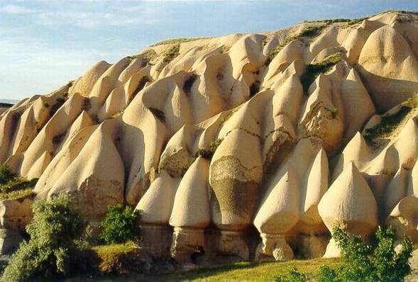 Volcanic Formation..
|
Aksaray is located on the Melendiz Cayi (Melendiz River) along the old trade route that connected Persia to the Aegean Sea. It was once the city of Garsaura that was later renamed Archelais but little of its ancient past survives. During the Seljuk era (1071-1300), Aksaray was transformed into an exemplary Muslim city where a hospital and schools were built. One of the first two Islamic theological schools, the Ibrahim Kadiroglu Medrese was built here in the 12th century. The other was built in Konya, one of Turkey's oldest continuously inhabited cities and the capital of the Seljuk Sultanate of Rum. These and later schools attracted some of the greatest Islamic scientists, philosophers and theologians of the age including Jelaluddin who escaped the Mongol invasion of Afghanistan. He is better known as Mevlana Jelaluddin Rumi, a renowned mystical Master and favorite saint of Konya.
The reign of Sultan Alaeddin Keykubat I (1219 - 1236) brought prosperity to the empire when he renovated the long neglected road system and constructed a series of hans (inns) along the way. Generally, they are massive fortress-like structures with impressive entrances framed by intricately carved honeycomb portals. Inside, a large courtyard with a central mescid (small mosque) is surrounded by arched porches where animals were tended. Another portal leads to the living quarters for travelers. Hans were located about a days distance apart by camel and they provided travelers with food, lodging, entertainment and protection. Twenty four miles to the west of Aksaray, the Sultanhan Caravanserai was the last overnight stop before reaching Konya. It was built about 1229 and has been partially restored. The Agzikarahan Caravanserai nine miles to the east of Aksaray retains its original features and is one of the best preserved in the area. This somnolent farming town now serves as a base for exploring the Ihlara Valley or as a rest stop on the way to Cappadocia but during the 13th century, it was an enclave of culture, refinement and scholarship that attracted visitors from all over the known world including the great Spanish scholar and mystic, Ibn El-Arabi.
A few miles past Aksaray, a good road leads to the main Nevsehir-Nigde highway by way of the Ihlara Valley and Guzelyurt. Rick Steves highlighted Guzelyurt in his Turkey travel video for television and now, even 'the pension where Rick Steves stayed' is offered as a place of interest for tourists! Guzelyurt is one of the most tourist friendly communities in Cappadocia with a multi-lingual aide who seems to materialize out of nowhere and whose job it is to assist visitors with practicalities like parking, food and lodging. Villagers and children will stop to chat and give directions to the 'antique city' of the old Greek quarter where the mosque was once an old Byzantine church that honored St. Gregory Nazianzus. He was born and died nearby and is prominent as one of the 4th century Cappadocian Fathers who defended the Nicene Creed against Arianism which denied the Divinity of Jesus Christ.
|
|
Formerly known as Karballa then Gelvere, Guzelyurt means 'beautiful land.' It is built on the cliffs surrounding a narrow gorge that is but a small appendage of the more impressive Ihlara Gorge. There are over fifty rock cut churches inside Monastery Valley which lays beyond the old village, past semi-troglodytic houses that line a narrow, winding road. People still live in these old cave dwellings and visitors are apt to see women baking bread in 400 year old communal ovens or children making mud pies on the roofs of their cliff houses carved in the rocks below. Guzelyurt has been declared a conservation area requiring new buildings to be constructed of natural stone so as to maintain its distinct Cappadocian architecture. The boxy, stone buildings with flat roofs and large arched doorways are more similar to houses of Northern Syria and Upper Mesopotamia than to structures in other parts of Turkey. This is hardly surprising because the earliest mention of Cappadocians by Herodotus in the 5th century BC refers to them as 'Syrians.'
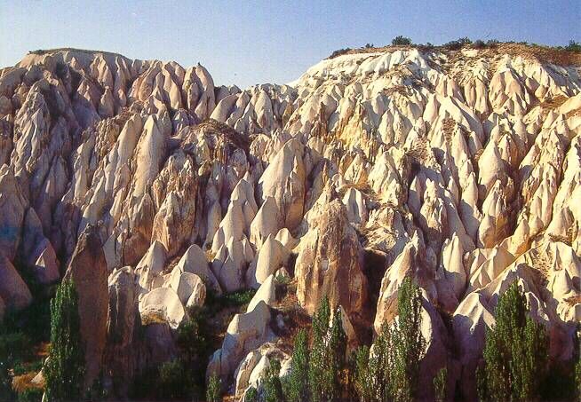
The Melendiz River finds its source in the numerous springs of the Melendiz Daglari and the adjacent Hasan Dagi to its west. These mountains comprise a series of currently inactive volcanoes that, over millions of years, deposited a thick layer (1500 feet) of volcanic lava, ash and mud. This material hardened to form a soft volcanic rock known as tufa which was overlaid with a thinner layer of hard basalt. With the passing of time, the Melendiz River has carved a steep sided gorge on its way toward the marshes of Toz Golu (Salt Lake) leaving behind expanses of flat, basalt topped plateaus that characterize this region. Further erosion of the basalt layer expresses itself in the surrealistic landscape of Cappadocia but in the Ihlara Valley (Peristrema), rock cones are only seen near Yaprakhisar and Selime.
Throughout the years, this verdant valley has remained relatively untouched by the tides of invaders that have swept the land. Sheltered by a natural barrier, the massive Hasan Dagi to the south, the valley is located away from the major travel routes that are still evidenced by the main roads from Aksaray to Kayseri and Kirsehir to Nigde. It has therefore served as a physical and an intellectual oasis for the people who have lived here. Hittites found refuge from the Phrygian invaders while early Christian monks sought its isolation in a remote corner of the kingdom during the 2nd century Roman persecutions and were later sheltered from the Arab invasions in the 7th and 8th centuries. The valley became an important center of monasticism that lasted from the 4th to the 14th centuries. There are an estimated 150 churches and several monasteries in the canyon between the villages of Ihlara and Selime. A walk through the tranquil 14 km gorge is a delight. The dappled light under poplars and wild olive trees as well as the constant murmur of the water provide relief from an unrelenting sun and the monotony of endless wheat fields that make up the Cappadocian landscape. Near villages, the river continues to be the focus of village life: women wash their laundry amid chatter and laughter, children splash nearby and shepherds bring their animals for a drink. The main churches are marked although a few have been closed to the public. The most popular churches are those in the canyon area between the villages of Belisirma and Ihlara. However, Yaprakhisar and Selime are more interesting architecturally with stone houses that extend into the rock caves. The village of Selime is named after the sultan whose conical tomb stands on the river's bank and numerous facades are carved into the cliffs at Yaprakhisar. For the adventurous, the entire length of the Ihlara Valley is a wonderful place for exploration. The children know the hidden entryways and they offer some of the most incredible 'tours' to be found in Cappadocia as they share their extraordinary playground, scampering up tracks through the rocks to a labyrinth of caves and tunnels that open to unexpected hideaways.
Only nine miles from Ihlara, the village of Helvadere sits among the foothills of Hasan Dagi. Its peaks are both over 10,000 feet high and its northern face is threaded with ribbons of snow where ravines have etched the mighty volcano. The mountain beckons for it abounds in secrets and legends. It has witnessed the comings and goings of Central Anatolia since the dawn of civilization. Roman ruins, Byzantine churches and Seljuk graves lay scattered along its northern slopes and mountain villagers tell tales of intriguing snake legends. In his book, Caves of God: Cappadocia and Its Churches, Spiro Kostof interprets the symbolism of the paintings in the Yilani Kilise (Snake Church) located across the bridge from the Tourist Pavilion in the Ihlara gorge. For one painting, he suggests that a woman is being punished for not nursing her children because 2 snakes are attached to her nipples. It seems likely that the real meaning may be hidden within the snake legends of these mountain people. While we long to uncover the secrets of Hasan Dagi, there is only enough time for a half an hour hike behind Helvadere to visit the ruins of Viransehir (Destroyed City). There was a large monastic complex here and remnants of a Byzantine fortress and two churches can be seen.
A drive through the region to the north of the Aksaray-Nevsehir road is to visit the true heart of Turkey. Numerous farming communities are located along the streams and rivers that empty into the stalwart Kizilirmak, Turkey's longest river that is over 800 miles in length. Farming in Turkey is generally highly mechanized, but here, reapers still wield the scythe and plants are sometimes hand-watered with scoops dipped into nearby irrigation canals. When the sun reaches its zenith, workers gather under shade trees for their midday meal and a well earned rest in a scene reminiscent of Bruegel's 16th century painting, "The Harvesters." This centuries old way of life continues, seemingly indifferent to the encroachment of mass tourism.
There are cavetowns and rock formations scattered within this area. Tatlarinkoy boasts an extensive semi-troglodytic complex but only a few caves are available to the public. The small Byzantine church has not been vandalized and its original colors remain rich and vibrant. A typical cave dwelling with several rooms can be explored and it is complete with 'telephone' (a special chute for talking to those on another level), toilet, kitchen, shelves and a large, solid, wheel-shaped rock that serves as a rolling door. Above the doorway is a compartment from which to attack an intruder who may have broken through the barrier. The main features of this cave dwelling are duplicated throughout Cappadocia. In Tatlarinkoy, cave entrances speckle the surrounding cliffs carved by the Acisu River. Some caves are used by farmers for food storage and animal shelters but many seem to have been completely abandoned.
|
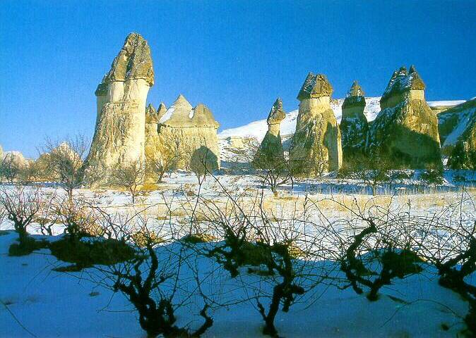 Pasabag..
|
Kayseri was already an ancient Hittite settlement called Mazaca when it was renamed Caesarea of Cappadocia by the Romans in the 1st century AD. Nearby, archaeological excavations at Kultepe have revealed that the area was first occupied around 4000 BC and known as Kanesh in ancient times. It was a powerful commercial trade and mining center around 2000 BC and 4000 year old Assyrian silver mines can still be seen there. Most of the artifacts from Kultepe are housed in the Archaeological Museum in Kayseri.
During Byzantine times, Caesarea Mazaca maintained its prominence as a city of commerce and trade as well as a major metallurgical center that specialized in the manufacture of heavy cavalry armor. Its schools were ranked with those of Athens, Alexandria and Constantinople. It must have been an affluent city because historical references have been made to its beautiful homes, elegant cuisine and the many almshouses that were built by St. Basil the Great, another Cappadocian Father and friend of St. Gregory Nazianzus. Much of its Byzantine years has been lost because the city was razed in the 11th century when it was captured by the Seljuk Turks and it lay abandoned for fifty years. Ruins of a 4th century monastery and Justinian's 6th century citadel that has been extensively renovated by the Seljuk and Ottoman Turks, still remain. Surprisingly, one of Caesarea Mazaca's culinary traditions has survived. They developed a type of cured beef called paston which was introduced to Hungary and Romania as pastirma by the conquering Turks. It was then adapted and carried to New York as pastrami by Jewish immigrants.
Under the Seljuks, Kayseri became prominent once again as the second most important city in the empire with many architecturally important structures. Theological schools, a medical school and hospitals were built here. As an important center of learning and commerce, Kayseri attracted an intellectual elite, merchants, tradesmen and skilled artisans. Today, Kayseri is a university town, a major agricultural center and enjoys a bustling trade in carpets and kilims.
Birds of the Reed Forests
To the south of Kayseri and Erciyes Dagi, the Sultansazligi or the Sultan Marshes is an extensive wetland area that envelops the Develi Plain. The road from Kayseri to the town of Develi affords a very scenic drive following the Karasu River to Tekir Yaylasi where a popular ski center is located on the eastern slopes of Erciyes Dagi. The road then descends the southern slopes of the mountain where the entire Sultan Marshes ecosystem spreads itself beneath the majestic, snow-capped mountain. On closer view, reeds sway to gentle breezes, iridescent blue waters shimmer in the sunlight and masses of pink flamingoes cavort in Yay Golu. This wetland area consists of two reed-covered freshwater lakes, Egrigol and Col Golu, to the north and south of the Develi Plain, Yay Golu, a saltwater lake between them as well as the surrounding marshlands. It is the largest wetland ecosystem in Turkey and is fed by numerous springs and streams from the surrounding mountains. Its location at the juncture of three continents makes it an important breeding ground for birds and over 250 species are found here. While the Sultan Marshes are of special interest to ornithologists, the pink flamingoes of Yay Golu are as impressive as those on Lake Nakuru in Kenya or Lake Manyara in Tanzania. There is a lookout tower at Ovaciftlik just east of the Kayseri-Nigde highway along the connecting road to Yahyali, a village where local women weave distinctive patterned carpets of world renown. The villages of Sindelhuyuk near Develi and Ovaciftlik are convenient for making arrangements to view the flamingoes of Yay Golu but boat rides on the various lakes can generally be negotiated from any of the villages that surround the area.
Underground Cities
Although referred to as "cities," the underground communities of Cappadocia probably served as temporary shelters rather than as permanent hidden cities. The incessant darkness is hardly conducive to life and some of the passageways are little more than crawling spaces that would have been intolerable in long-term situations. No one is certain as to the number of underground communities that exist or even by whom they were built. The two largest communities that have been unearthed are located at Kaymakli and Derinkuyu, 20 and 30 kms. south of Nevsehir on the Nevsehir-Nigde road. It is thought that the Hittites may have excavated the first few levels in the rock when they came under attack from the Phrygians. These chambers were later expanded into an extensive troglodytic complex by Christians escaping the Arab invasions of the 7th and 8th centuries. Discreet entrances give way to elaborate subterranean systems with air shafts, waste shafts, wells, chimneys and connecting passageways. The upper levels were used for living quarters while the lower levels were used for storage, wine making, flour grinding and worship in simple chapels. Everywhere, walls have been blackened from the use of torches. There is a connecting tunnel between Kaymakli and Derinkuyu that allowed three people to walk through at the same time but it is not available to the public as parts of the tunnel have collapsed. 0nly 10 kms. to the east of Kaymakli is another cavetown at Mazikoy that may be connected with Derinkuyu but this remains to be proven. This community was built within the walls of a cliff. Unlike Kaymakli and Derinkuyu, there are no stairs or grades that pass from one level to the next. Instead, the different levels are well defined with connecting tunnels through which people climbed up or let themselves down by means of footholds carved into the walls of the shafts. Mazikoy is often bypassed because it is a smaller community, its location is away from the main road and a certain agility is required to fully appreciate its features.
Rock Cut Churches and Monasteries
Many settlements in Cappadocia were established primarily as monastic communities. As Bishop of Caesarea Mazaca in the 4th century, St. Basil the Great wrote the rules for monastic life that are still followed by monks and nuns of the Greek Orthodox Church. He advocated community life, prayer and physical labor rather than the solitary asceticism that was popular at the time and it was under his guidance that the first churches were built in Goreme Valley. Here, a number of small communities with their own churches formed the large monastic complex that is now the Open Air Museum. Hundreds of churches are reported to have been built in this valley but no churches from St. Basil's time remain. In Goreme, the Tokali Kilise or the "Buckle Church" is easily the loveliest of the churches with graceful arches and beautiful frescoes.
The most impressive monastery in Cappadocia is the Eskigumus Monastery to the east of Nigde off the Kayseri-Nigde road. It is the most southerly of the Cappadocian monasteries and lies close to the route taken by the invading Arabs who traversed the Tarsus Mountains from the south to plunder Kayseri in the 7th century. This route follows the Tarsus River through a precipitous defile called the Gulek Bogazi. It was known in the ancient world as the Cicilian Gates and was used by Alexander the Great in his eastward campaign against the Persians. The nondescript entrance to the Eskigumus Monastery was designed to shield the monastery complex from invaders passing by. It was so successful that the monastery was not discovered until 1963, having escaped the vandalism to which many of the Cappadocian churches and monasteries were subjected. The large inner courtyard boasts high walls surrounded by monastic rooms and storage chambers. The main church is spacious and airy and its well-preserved frescoes are considered to be the best example of Byzantine art in all of Cappadocia.
Pigeon Houses
Near Uchisar is a valley that has become quite popular with hikers. It is known by many names (Valley of the Pigeon Lofts, Dovecote Valley, Pigeon Valley) but they all refer to the thousands of pigeon houses that have been carved into the soft tufa since ancient times. Although they can be found throughout Cappadocia, they are especially plentiful in this valley which must have one of the greatest collections of pigeon lofts in the world. They were carved wherever space allowed including abandoned caves and the walls of collapsed churches. They lack the architectural interest of the doocots of Scotland or the elaborate Persian pigeon towers but their sheer numbers are astonishing. In Cappadocia, pigeons have long been a source of food and fertilizer. The advent of chemical fertilizers has reduced the use of pigeon fertilizer. However, some farmers still maintain their lofts because they insist that the reputation of Cappadocian fruits as the sweetest and most succulent in Turkey is entirely due to the pigeons' droppings.
Best Times to Go: Cappadocia is generally cooler than the popular coastal areas of the Mediterranean and the Aegean. April to mid June and September to October are the best months for avoiding the intense heat and crowds of summer.
Getting There: Turkey has excellent bus and dolmus (minibus) service. Bus service to Cappadocia is available from Istanbul, Ankara, and the major cities of Turkey. Drop off points differ according to the city of origin so take a bus from wherever you are to whatever destination in Cappadocia is available then use a taxi or the dolmus service to get to the towns that you may want to visit.
Travel agents in major cities in Turkey all offer tours to Cappadocia. If time is an issue and you have no other options for visiting the area, it is better to take the tour rather than to forgo the region but be aware of the limitations of such tours which have a propensity for spending too much time at the carpet shops.
The main airport of the region is located in Kayseri and there are regular flights from Istanbul by Turkish Airlines (THY). Buses are available from Erkilet airport to the otogar in Kayseri. Argeus Tours (Tel. 90-384-341-4688) has a shuttle service from the Airport to Goreme and Urgup.
Clothing/Gear: Modest, season appropriate clothes are suggested for visits to Cappadocia. Immodest clothing for women (shorts, short skirts, tank tops, tight fitting clothes) still invites unwanted attention in this conservative region, especially in the less visited villages. Long pants are recommended for those who want to explore cave dwellings as some crawling may be necessary and the tufa surfaces can be quite rough. Be sure to bring a wide brimmed hat, sun tan lotion, and comfortable shoes.
When traveling in Turkey, it is a good idea for women to bring a long skirt, light sweater and pretty shawl. They can quickly be slipped on over casual clothes to dress up for dinner or to become appropriately dressed when visiting the mosques.
General Information: Those who plan to visit other areas of Turkey should consider flying since distances are so great between the different areas of interest. Turkish Airlines offers coupons for national flights in conjunction with their airline tickets from the US and Europe. These coupons are excellent bargains that cost - per leg. Bus travel within Turkey is easy and inexpensive but heavy smoking by Turks make long distance travel uncomfortable for those who are sensitive to smoke.
It is easy to get around the main areas of Cappadocia by dolmus service which is inexpensive and offers regularly scheduled trips. However, service to the less traveled areas is sporadic and not always convenient. A variety of one day tours are offered by numerous local tour companies at a cost of about per person per day. It is better to rent your own vehicle or to hire a car and driver. A rental car costs - per day and hiring a car and driver costs about - per day. Putting together a small group will make this option more cost effective. Avis has an office in Urgup (tel. 90-384-341-2177) while local car rental companies or a car and driver may be found by asking at your hotel.
There is a substantial difference in quality between similarly priced hotels in Cappadocia and those of the Aegean coastline. The Cappadocia area boasts some modern western style hotels but they are quite expensive (over per night). Fortunately, there is a good selection of reasonably priced pensions and small hotels, some of which provide unique lodgings such as cave dwellings and converted monasteries. Restaurants are plentiful and if you cannot read the menu, you are welcome to peer into the pots to make your selection.
Planning Tips:
Do allocate several days to explore Cappadocia. A two or three day tour is hardly sufficient to experience this truly unique area.
Do include Konya in your Cappadocian itinerary. It was the once known as Iconium under the Romans and later became the capital of the Seljuk Sultanate of Rum. The best examples of Seljuk architecture and calligraphy can be seen here.
Do respect the conservative culture of rural Turkish life. Modesty and polite manners are appreciated.
Do pace yourself in the summertime as the heat can be quite fierce. Be sure to keep yourself hydrated.
Do try to vary your activities. Unless you are a Byzantine specialist, visiting the 50th rock cut church in the same day becomes a blur.
Do explore the area around Guzelyurt. Particularly interesting is the nearby Kizil Kilise (Red Church), a 6th century cruciform church with a dome that sits on top of an unusual, octagonal structure. This graceful, little church was constructed from red trachyte, a type of volcanic rock.
Do visit the rock fortress of Ortahisar, the spectacular Devrent Valley, the lush Soganli Valley and other well known sites. These areas have not been mentioned only because substantial information is already provided in most guidebooks.
Do purchase a good road map prior to leaving home. They are difficult to find in Turkey, especially outside the main cities.
|
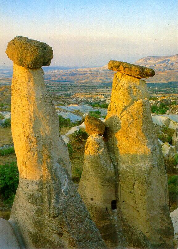 Mother, Father and baby Fairy Chimneys in Urgup..
|
GOREME
--------------------------------------------------------------------------------
One of the oldest settlements of the region is Goreme. Especially during the expansion period of Islam, this small town was occupied by the Christians who were under attack by the Arabic Muslim conquerers. Some of the earliest churches in this area date back to the 7th century A.D. St.Basil, from Kayseri, established the first monastry in Goreme to educate missionaries.
Goreme was an important settlement even before the Christian era. The people of the town were living in these carved rock houses. Some of these houses were converted into the churches later.
Some of the rock structures were used as burial ground. You can see one of them when you are entering the town, in the form of a rock pinnacle which contains a mortuary chapel with a small facade.
The El Nazar valley which is 3km. to the east of Goreme, where the fairy chimneys house some early era Christian churches. The Church of Kiliclar and the Church of Madonna are two of the most important ones.
CHURCHES AROUND GOREME
--------------------------------------------------------------------------------
APPLE (ELMALI) CHURCH :
This is one of the smallest and the most recent churches of the area. It was built in the 11th century. It is cross shaped in the ground plan.
The church was carved into the rock with a dome ceiling and pillars. Four columns support this dome. There are some frescoes remained to current time. These wall paintings represent the raising of the Lazarus, the last supper, the crucifixion, angels and some other holly figures.
--------------------------------------------------------------------------------
CONVENT :
The convent was located across the monastery. The first floor was used as a cellar, kitchen and living area. The church was on the third floor. The rest of the convent was used as refuge. It was known to be carved into the rock, during the 11th century.
--------------------------------------------------------------------------------
DARK (KARANLIK) CHURCH :
This was built in the 11th century in the form of a monastery. It is accepted as one of the best examples of Byzantine art of that century. The art of the church was commissioned to a professional artist by four benefactors who were portrayed in the frescoes. The small opening looking out on the narthex is the only source of light into the church. This helped to keep the frescoes in good shape throughout the ages. It is considered to be the best preserved environment in the area reflecting the 11th century Byzantian art.
The frescoes reflect scenes from the New Testament. The most spectacular ones are : Christ Almighty on the main dome, the baptism, the last supper, the crucifixion, the Christ's betrayal and some Saints and Evangelists.
--------------------------------------------------------------------------------
SNAKE (YILANLI) CHURCH :
It was built into the rocks in the 11th century. It has a low ceiling and long nave. As you enter you see a picture of Christ and the founder of the church. There are frescoes on the other walls, showing St.Basil, St.Thomas and St.Onouphrios. On the other wall St.Theodore is shown struggling with a snake.
The pictures of emperor Constantine and his mother are also shown supporting the cross with their hands.
--------------------------------------------------------------------------------
THE CHURCH OF ST.BARBARA :
This 11th century church has two columns supporting the ceiling and it is carved into the rock. Its frescoes show St.George and St.Theodore.
--------------------------------------------------------------------------------
CHURCH WITH A SHIELD :
This 11th century church is the biggest carved-rock church in Cappadocia. It is on the main road to Avcilar, to the right. It is accessed after a long vestibule to the west.
There used to be a shield hanging on the ceiling long time ago. This does not exist anymore but the place where it was connected to the ceiling is still visible. At the eastern end of the nave which is connected to the vestibule there are four arched columns supporting the structure. There is an elevated corridor behind this nave.
The church with a shield is one of the most noticeable churches in the region with its size and spectacular frescoes.
URGUP
--------------------------------------------------------------------------------
The ancient town of Urgup lies just next to the road from Nevsehir to Kayseri. The town is built at the slope of a rocky hill. The hill is made of volcanic tuff and most of the houses were carved out of this soft rock formation. The houses next to the top of the hill were deserted a long time ago. The town reflects a beige earth color from a distance. The rest of the carved rock houses are used as sheds these days.
The view of the new tourist resort and the museum buildings next to the town match to the surrounding landscape. Whole area is covered with strange and unique land formations. The sudden slopes of colorful gorges, the so-called fairy chimneys, natural and human-made caves give a super-natural character to the environment.
The fairy-chimneys are in fact tall pinnacles made of tuff with a large rock sitting on the top. They were established through the geological movements and the erosion due to the atmospheric conditions.
There are a number of early Christian churches, monasteries and chapels carved out of this volcanic tuff material in the surroundings. The town is known to be the residence to the bishops, during the Middle Ages.
NEVSEHIR
--------------------------------------------------------------------------------
One of the oldest settlement points in Cappadocia is Nevsehir. The city is the capital of the surrounding large province. Old name of the city was Nissa and during various periods it had a population of 150,000. It is located on the slopes of a large volcanic tuff hill.
It is understood that the city was occupied since the Neolithic Age. There are some artefacts documenting this very early settlement place, found in the nearby tumulus of Igdeli Cesme. It is also known that Nevsehir was an important town occupied by Hittites because its close position to Kizilirmak (Halys river). During the following ages, it has been conquered by the Ionians, Cimmerians, Assyrians, Meds, Persians, Romans, Seljuks and finally the Ottomans.
There is a Byzantine era citadel on the summit of the hill which is surrounded by the city today. The second important monument of the inner city region is the "Mosque with the Leads" built by Damat Ibrahim Pasa, the influencial Ottoman vizier who was born in Nevsehir.
The Rock Mosque (Kaya Camii) is also an important historical site worth seeing.
--------------------------------------------------------------------------------
|
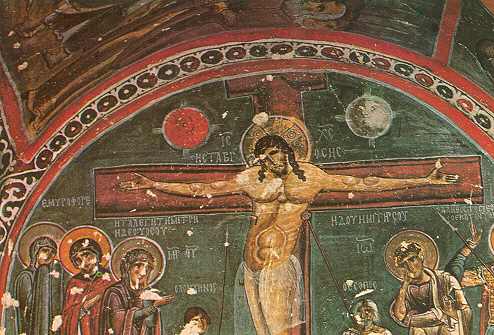 The Crucifiction
|
ORTAHISAR
--------------------------------------------------------------------------------
The distinguished view of the honeycombed rock in the center of Ortahisar gives this Cappadocian town a unique appearance. This sharp rock formation in the middle of the town is called "Sivri Kaya". Since the early ages, the human settlers carved their houses into this monumental rock formation. These houses have been converted into storerooms nowadays.
The rest of the town was built from the same stone material in masonry but in a modern style. There is still a great harmony between the early carved rock settlement center and the recent town center. They both reflect a close cultural link with the surrounding landscape by utilizing the volcanic tuff building material extensively.
UCHISAR
--------------------------------------------------------------------------------
This spectacular corner of Cappadocia is only 3km. from Goreme, on the way to Nevsehir.
Uchisar is a tiny settlement place next to a large triple rock formation. There is a citadel on the summit of this nearly 100m tall rock. You will see a magnificent panoramic view of the nearby gorges and valleys from this citadel. There are a large number of houses carved into these rocks. Some walls of these early houses were eroded and open to the sky now.
The nearby hotel which was built in a similar shape to these rock settlements fits perfectly to this bizarre landscape. Locals live in a tiny village which only supports the panoramic view of the valley.
ZELVE
--------------------------------------------------------------------------------
The ancient settlement place of Zelve is one of the most spectacular points in Cappadocia. The narrow valley in which the old settlement of Zelve is located, has a large number of carved rock houses and churches.
During the 1950s, the local people were evacuated to new Zelve, which is nearby the old one, due to the deteriorating conditions on the walls of the houses. The old town is open to visitors now.
Zelve had always been a secure hiding place for early Christians against the Romans and later on the Arab conquerors.
The "Church with the Grapes" or "Uzumlu Kilise" in local language, is one of the most interesting churches in the area. The frescoes, painted on the walls, showing bunches of grapes were ritualistic symbols of some earlier religions, popular in the region and also representing Christ according to the Christian belief.
There is also one mosque carved into the rocks remaining from early Muslim era.
AVANOS
--------------------------------------------------------------------------------
The town of Avanos is 18kms. away from Nevsehir to the north. It is located to both sides of Kizilirmak (Halys). This town was first settled in the Bronze Age. We have excavated some artifacts from this age in the nearby tumulus of Toprakli. Its previous name was Vanessa.
The town is famous with its hand-made pottery and hand-knotted carpets. The ferrous soil reserves around the town helped to the creation of local pottery industry since the early ages. This soil gives a red color to Halys river and that is why it is called Kizil (red) - irmak (river) in the local language. The area is also well known with its vineyards for many centuries.
The geometric and local plant figures decorate the terra-cotta pots and locally knotted carpets, traditionally
PASABAG
--------------------------------------------------------------------------------
The vineyard of Pasabag is only 3kms away from Zelve. It is also called the Valley of Monks. Currently, there is a vineyard and a number of tuff cones standing right next to the road.
There used to live Christian stylites and hermits in these carved rock cones. They used to hide in these specially carved stone monasteries. Some of these cones were only carved in the upper section for better protection against the aggressors.
The Simeon monks was also living in one of these cones.
VALLEY OF SOGANLI
--------------------------------------------------------------------------------
The valley is approximately 25kms from underground city of Derinkuyu, to the northeast. The tall rock formations made of volcanic tuff were carved by the early Christians for making a number of churches. There are also a large number of pigeon houses marked with white rings on the facade. Some of the churches were abandoned earlier and converted into pigeon houses during the following ages. Most of them are restored now to their original shape.
One of the most notable churches in the area is the "Church with the Black Heads" or "Karabas Kilise" in local language. The faces of the saints on the wall paintings were blackened by oxidation of the elements in the paint material throughout the ages, caused this church be named like this.
Another one, the "Church with a Dome" or "Kubbeli Kilise" is famous with its large dome shaped ceiling and two storey structure. This carved rock church belonged to two different churches, one on each floor.
The "Church of St.Barbara" consists of two churches in one structure, also. The barely visible figures of St.Barbara on the walls indicate that the churches were devoted to St.Barbara. The state of frescoes on the walls has been deteriorated badly.
Finally, the "Church with the Beast" was carved into the rock in a simple square plan. The name of the church comes from the fresco, which indicates a wild animal standing next to St.John.
|
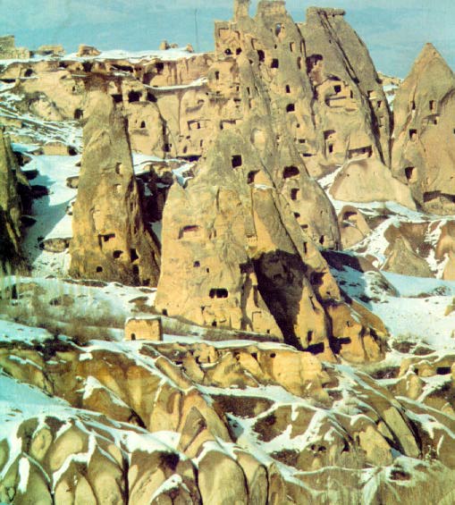 Cappadocia in winter..
|
VALLEY OF IHLARA
--------------------------------------------------------------------------------
The deep canyon was formed by the water flowing down from the Melendiz mountains and the Hasan Dag throughout the millenniums. It is 95kms to the south of Nevsehir. Ihlara valley has a very different character than the whole Cappadocia region. There are tall steep rock walls surrounding the valley on both sides. It has a unique picturesque value along the 16kms long canyon. The valley reaches to the cave villages of Ihlara and Selimiye on both ends.
There are more than hundred churches, carved into the rock walls of the valley. Some of them are very difficult to reach. These churches are from the 4th and 9th century. The art in the churches was Syrian and Egyptian influenced. This is very obvious with its simplicity and limited color variety.
Among very different churches, in style and colors, we noticed a few of them with some remarkable values. The "Church with columns" or "Direkli Kilise" in the local language, has a large central dome supported by four columns and the walls are decorated with frescoes. Another one is "Church with Snakes" or "Yilanli Kilise", which was named after the painting on the wall, with snakes attacking the sinners.
The "Church under the trees" or "Agac Alti Kilise", is named after the tall and dense trees of the valley which was protected against the cold central Anatolian weather by the walls of the canyon throughout the millenniums.
You will see plenty of other very interesting churches along the way your journey to the other end of the valley.
UNDERGROUND CITY OF DERINKUYU
--------------------------------------------------------------------------------
This huge underground city of Derinkuyu was capable of accommodating 20,000 inhabitants for many centuries. It is located 10kms to the South of Kaymakli. The city was abandoned a long time ago and stayed hidden under the ground until 1968.
The founders of this deep settlement place were thought to be Hittites. During the millenniums after Christ the city was utilised by the early Christians for hiding purposes.
Only the first 8 floors have been excavated until now. It is estimated that there are many other floors existing underneath and the city is interconnected to the other subterranean cities in the area. The only other underground city, which was discovered recently, is Kaymakli. Scientists estimate that there might be at least 30 more underground cities, still undiscovered, in the area.
The discovered area of Derinkuyu is about 4 kilometer squares already. There is a vast network of air shafts, water wells, water tanks at the bottom and various access tunnels, in the city. There are also a vast number of kitchens, living rooms, stores, meeting rooms, cemeteries, churches and corridors connecting different segments of the city to each other. This is a fully established city with all necessary facilities inside.
UNDERGROUND CITY OF KAYMAKLI
--------------------------------------------------------------------------------
This subterranean city is located 20kms to the south of Nevsehir. The city is estimated to be occupied since the 5th century B.C.
During the following ages, it is known to be used by the Christians as a refuge against the Arab aggressors. Approximately, 15,000 people used to live in this underground city. We discovered only 8 floors until now. The city was sub-divided into separate sections for better defense purposes. Each section could be isolated from each other by closing the mill-stone shaped round rock gates with a diameter of 1.5m. The passages between these sections are about 30kms long. The corridors are very narrow. But the living rooms, meeting halls, churches and other facilities are very comfortable.
The storage rooms were capable of storing enough food for the residents for many months. The air shafts and water wells were adequate for 15,000 people, living all together for a very long time.
|
Tell me what you think!
Visit my guestbook and leave your comments or suggestions.
|
|

